Chadx
Well-known member
- Likes
- 215
- Location
- SW Montana
I have a GPS/Trail/Mapping app that I loaded on my Stark phone (onX Offroad in this case, but question applies to any mapping/trail app).
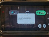
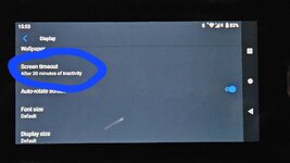
I've found that apps work and run normally on the phone, but while riding, only in the background. The issue is, every time you put the bike in drive, the display changes to the Varg gauge. I experimented with turning off the Stark phone's bluetooth, so it would not communication with the bike since it's not needed, but the phone keeps popping up a message saying to enable bluetooth to communicate with the bike. So that doesn't work.
What I've been doing is stopping and switching over to the app when I need to refer to it for directions. To the app, I come to a stop and within a second or two (faster than I can take off my glove), the little "home/house" button appears. I can click on that, hit the button to show all running apps, and select the app, then I can look at, and use, the app's map. While it is easier than pulling my personal phone out of my riding pants cargo pocket, unlocking, and looking at the app on that, I'd much prefer if the map could be displayed on the Varg screen as I'm riding for on-the-fly navigation.
I searched this forum and other sources and wasn't able to find anything. I'll reach out to Stark as well, and share their response, but curious if anyone has determined a way to display anything other than the Varg gauge while you are riding. Thanks.

